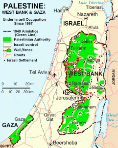
The current country boundaries in the Middle East are products of post World War I efforts to divide the Ottoman empire for oil. In the case of the Palestinian Territories, the country’s boundaries have been shifting since the creation Israel in 1948. The ensuing Arab-Israeli wars lead to Israel gaining control of much of Palestine. Palestine was further divided when Hamas took control of the Gaza Strip in 2007. The West Bank is currently governed by the Fatah Party.
Map of Palestine as of 2007, Israeli Settlements are marked
